Geography
Climate
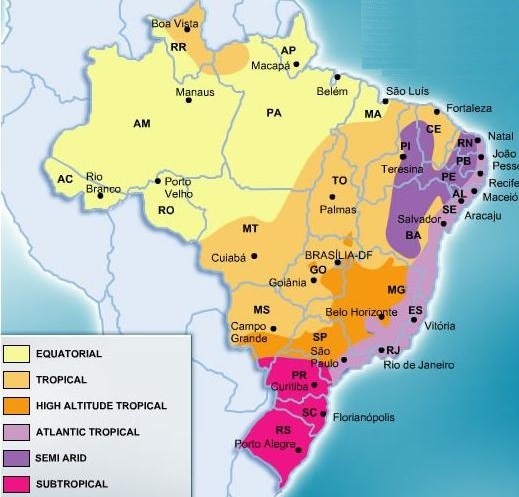
Due to the varying heights above sea level as well as the proximity to the coast in Brazil, the climate varies from region to region. There are five climatic zones in Brazil:
1. The Equatorial Zone
2. The Tropical Zone
3. The Semi-Arid Zone
4. The Highland Tropical Zone
5. The Subtropical Zone
The Equatorial Zone:
In most Equatorial Zones rainforest can be found due to year-round precipitation and humidity. There is no defined winter season in this zone and no period in which it is particularly dry. Rainfall is almost always heavy and occurs frequently all through the year, yielding to luscious vegetation. Night time temperatures may drop significantly from those during the day. However, the daily temperatures are similar because equatorial zones usually lie on the equator. Because it is usually overcast in equatorial zones, the daily highs do not often exceed about 91 degrees fahrenheit, and are usually at a comfortable temperature between 77 and 82 degrees. In Brazil most of the Amazon rainforest is in the Equatorial Zone.
The Tropical Zone:
This climatic zone is found in the Tropics. The temperatures of these zones are consistent all year round, meaning that there really are no defined seasons in terms of climate. In fact, the only distinguishing characteristic of the different seasons is the amount of rainfall that occurs. In areas of rain forests, the average rainfall is at least 2.4 inches. To qualify as a Tropical Zone, an area must have a mean temperature of over 64 degrees fahrenheit all year round. Cities in Brazil that are in the tropical zone include, Rio de Janeiro, Sao Paulo, and Brasilia.
Semi-Arid Zone:These zones receive less rain than they need to make up for evaporation, but not to the point that it is qualified as a desert. This climatic zone is the halfway marker between deserts and humid forests. In semi-arid zones, the vegetation includes shrubs and grasses, instead of a lot of trees. Cities in Brazil that are in Semi-Arid climates include the city of Teresina.
Highland Tropical Zone:
This is Zone is also referred to as an Oceanic Climate or a Maritime Climate and is found along the coast of Brazil. It is characterized by cool summers and warm to mild winters. The annual temperature does not vary by significant amounts. Rainfall is consistent throughout the year. For a region to qualify as this zone, the area must experience an annual average temperature that does not exceed lower than 64 degrees fahrenheit, just like the Tropical Climatic Zone that was mentioned earlier. Cities in Brazil with this climatic zone classification include, Belo Horizonte and Northern parts of Sao Paulo.
Subtropical Zone:
This zone refers to the areas that are just outside of the typical Tropical Zones. It is hot, but not quite as humid as Tropical areas. Winters are mild to cool. In Brazil, the Subtropical Zone experiences different amounts of rainfall, depending on the area's elevation above sea level.
In general, the coastal cities of Brazil can get very hot, while those that with higher elevations usually enjoy milder temperatures and conditions. Northeast Brazil is the driest part of the country, resulting in limited vegetation, while the Amazon Basin has the highest levels of precipitation and is, therefore, home to many fascinating plants and animals.

This is a Climograph For Manaus, Brazil. Manaus is located in the Amazon Rainforest, which is classified in the Equatorial Zone.
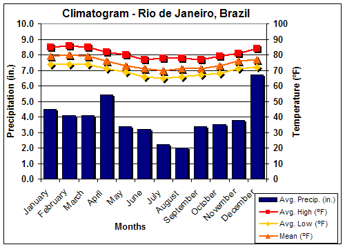
This is a Climograph for Rio de Janeiro, Brazil. Rio de Janeiro is located in the Tropical Climate Zone.
The Tropical Climatic Zones and The Equatorial Zones are both very different. These climographs allow us to compare the two climates. For example, we can see that the temperatures (and in turn the precipitation) varies more in Manaus than in Rio de Janiero.
Biome/Ecosystem

Their is no real distinction from Winter to Summer in Brazil. In fact the biggest difference in Temperature each year averages around 20-30°F. The image to the left is The Amazon during the winter.
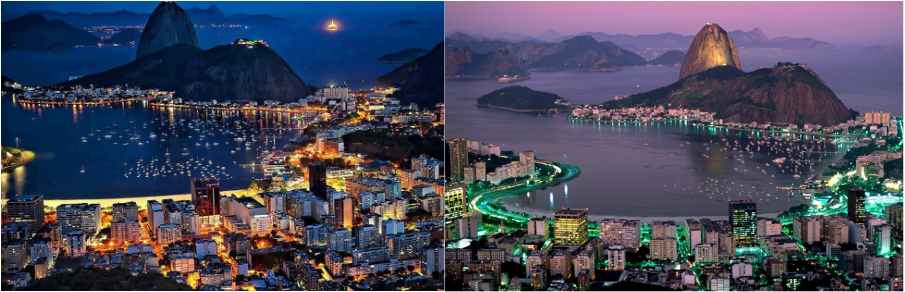
Rio de Janiero: Summer Vs. Winter
SUMMER WINTER
As you can see their is minimal difference between Summer and Winter
.
.
Brazil Biome Facts
- Because Brazil is in the Southern Hemisphere its seasons are backwards than those of the United States. Meaning that when it is Summer in the United States it is winter in Brazil and vice versa.
- 90% of the vegetation in Brazil comes from the Amazon rainforest.
- Brazil has one of the highest animal diversities of any country in the world.
- Brazil has the most known species of plants in the world.
-Brazil is also home to the biggest Rainforest in the world.
Flora and Fauna

Brazil is home to a wide array of animals, including the Scarlet Macaw. The macaw can prosper in Brazil because of the diversity of the Amazon Rainforest. These birds eat small insects and some plants.

The Amazon Rainforest is also home to the red-eyed tree frog. These animals can prosper because of their ability to adapt and their incredible survival instincts. The consume leaves of trees and plants and insects.

To the left is the Amazonian Water Lily. As it's name says, it grows and prospers in the Amazon rainforest, specifically in the Amazon River. It is about 5 times the size of a traditional Water Lily. This plant is indigenous to the Amazon Region in Brazil.

This is the Brugmansia, a trumpet flower that is indigenous to Brazil as well. It grows in many places and is used for decoration a lot, however some species of this plant are poisonous.
ENVIRONMENTAL CHANGE
- The most occurring natural threat to Brazil (as far as disasters go) are floods. About 80 floods have occurred in Brazil over the past 30 years. The complete occurrence chart is shown below:
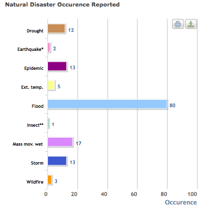
Floods may occur the most in Brazil, but they are not the most life threatening disasters to hit. Below is a chart that displays the damage that each disaster does on the region:

- Natural Disaster numbers have neither increased nor decreased in the past 30 years, as a matter of fact it has been pretty consistent. Of course we are more advanced in terms of dealing with bad weather than we were in 1980.
- Precipitation and Temperature has always been pretty consistent, however recently droughts have tampered with this consistency and in turn affected temperatures to be really hot.
- Because Brazil is so large there are many forms and ways of agriculture. In effect, there is no major change in agriculture when a natural disaster occurs.
Everyone knows that trees in the Amazon rainforest are being cut on a daily basis in order to make paper. This obviously has a major effect on the many flora and fauna that live in the area. For example, the trees are considered flora and they are cut down, which can actually lead to more floods because the tree roots are not there to absorb water anymore. On the fauna side, now the home of most animals are being destroyed as well as their food supply and shelter.

Depicted Here is an area where trees have been cut down in the Amazon Rainforest. The process of trees being cut down is called Deforestation.
HUMAN GEOGRAPHY STATISTICS
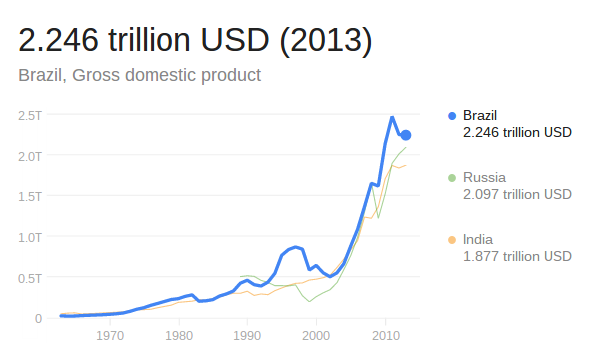
GDP or Gross Domestic Product, is arguably the most important indicator on the health of a countries economy. This means that the higher the GDP is, the "healthier" countries economy is. Brazil had a GDP of 2.246 trillion USD in 2013. This was ranked as the seventh highest GDP in the world just lower than Germany and higher than Russia.
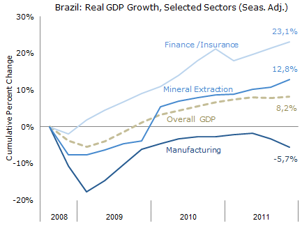
The chart below shows Brazil's GDP growth since 2008:
-Brazil Exports more than it Imports.
- Brazil is a Creditor Nation, this means that the country has a cumulative balance of payment surplus.
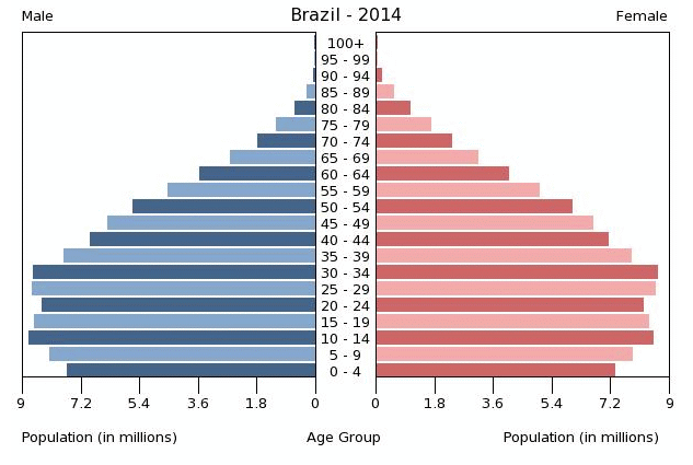
This is a Population Pyramid. This helps geographers predict what the future in terms of population would be in specific regions. As you can see older people are far outnumbered in Brazil. This indicates a population increase in the future.
